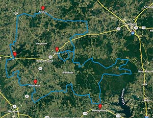
The Cheeseburger Loop located in central Texas is a great overland trail providing mostly mild terrain through beautiful forests and pasture land. Providing a loop configuration, you can choose which direction you want to travel in and which ever starting point you prefer.
What To Know about Cheeseburger Loop Trail:
- While most of this trail is on dirt or paved roads please note that heavy rains can change the difficulty making some portions of the trail impassable due to mud or high water.
- Portions of this trail pass by rural private homes – please slow down when you pass them to avoid causing unnecessary noise or kicking up dust.
- Some ranchers and farmers take exception to you petting their livestock – you’ve been warned.
- Never trespass… especially in Texas with our gun laws.
Location: Located between the towns of New Waverly to the east, Montgomery to the south, College Station to the west and Bedias to the north, this trail is 170 miles long and travels mostly forest service roads, country gravel roads and some paved roads. There is a bridge that was washed out years ago that is scheduled to be rebuilt but until then will require a detour.
Duration: The Cheeseburger Loop can be done in one day or over a weekend (two days). Several of the roads will require a slower speed thus extending the travel time. If done in one day it would be a full day. You might consider one of many camping spots along the way to make it a full weekend overland adventure.
Lodging/Camping: Part of the Cheeseburger Loop is located in the Sam Houston National Forest where many camping spots are available. There are many private camping and RV locations in the area as well. Hotels and motels exist in major towns along the route.
Restaurants: There are many great restaurants along the Cheeseburger Loop, too many to list, but check out the local joints, the mom and pop burger spots, and the food trucks along the way.
Cheeseburger Loop Trail Map: There are several copies of the Cheeseburger Loop Trail floating around on the internet. Most follow the same path though there may be slight variations. Here is a version from AllTrails: Click here.
Paper maps of Texas trails always work – even when your smartphone battery dies. Check out our curated selection of maps.

– Page Contains Affiliate Links – Why? (click here to expand)
We lose money every month producing the TX:GX Overland website and YouTube channel. Creating content takes time and money – we have to pay for:- Website and WordPress hosting
- Trip videos that cost money for fuel, admissions fees at parks/events, and wear and tear on our vehicle
- An enormous amount of our time producing this site and the videos (I won’t even begin to calculate that cost!)
– Who Our Affiliate Links Benefit (click here to expand)
TX:GX Overland is about experiencing the outdoors and doing so in a responsible, sustainable way. Without the trees, the forests, the clean babbling brooks and the open trails we enjoy while overlanding we simply couldn’t exist. Therefore, we are committed to helping organizations that support our outdoor adventures. Though we do not make a profit from the TX:GX Overland website or YouTube channel we still make donations to worthwhile causes. We make donations to the following organizations:- OneTreePlanted
- Tread Lightly


